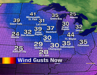
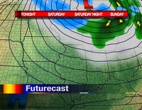
 At 3:00pm today, winds were gusting around tropical storm force through much of the Upper Midwest! The center of low pressure is located near Sault Ste. Marie, Ontario this afternoon. Believe it or not, winds adjacent to the low aren't all that strong! We've got an area of high pressure that is developing now over Oklahoma, Arkansas, and Texas. As this intensifies, it brings a higher gradient between the high and low pressures. You can see that by looking at the isobars (lines of equal pressure) on the Futurecast to the left. The closer the isobars are on a map, the more wind is moving through the atmosphere. In this
 case winds are spiraling around the area of low pressure, so we've got cold, northwesterly winds! Once this low pressure exits (on Saturday) we'll see more pleasant conditions with moderating temperatures.
The problem with this storm departing is that another system will develop and move into the Great Lakes for early next week...essentially taking this one's place. However, none of the computer models are generating this much cold air. Thank goodnesss! -ERIC


No comments:
Post a Comment