
 Quite a winter storm is shaping up for high plains of Colorado! Many locations along I-25 are under Winter Storm Warnings and Blizzard Warnings for Thursday. While most locations were in the middle to upper 50s on Wednesday, temperatures will crash. An area of low pressure will rapidly deepen (Meteorologists call this event a "bomb"). The "bombing" low will cause winds to gust near 50 miles per hour over the front-range of the Rockies. Denver could see near six inches of snow with some areas around Colo. Springs and Pueblo near a foot!
For more information, check out our affiliate websites www.9news.com and www.koaa.com.
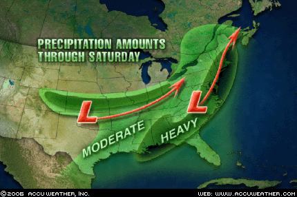 For us, we'll see only rain...but more importantly, only a little rain! The current storm track takes the powerful low from Oklahoma to Ohio by Friday. (Image courtesy of Accuweather.com) Northern Illinois/Southern Wisconsin will be on the northern fringes. While quite a thick deck of clouds is expected, rainfall will likely only add up to an 1/8 of an inch here. Some areas downstate could receive in excess of an inch.
With this system tracking south, it'll likely allow us to clear out a little bit over the weekend. It'll still be blustery and cool on Saturday, but Sunday will feature quite a bit of sunshine! -ERIC


No comments:
Post a Comment