
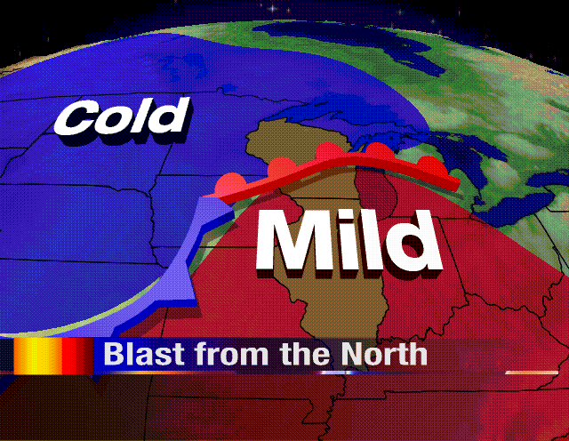
Over the past couple of days, temperatures have been fairly warm for the end of November and the upcoming days are going to be no different. Highs over the past weekend reached the upper 50s and lower 60s, and we'll continue that trend straight through Wednesday. The reason: a very strong warm front just to the north of the Stateline is helping to usher in warmer weather straight from the Gulf of Mexico.

But things are going to be changing by Thursday. A strong cold front responsible for the 20s and teens in the northern Plains will sweep through the Great Lakes late on Wednesday/early Thursday. Rain will likely change to snow during the overnight and could even linger into Thursday. It will definitely be the winds of change. Gusty northwest winds will come howling in keeping temperatures by the end of the week only reaching the lower 30s and overnight lows in the upper teens and lower 20s. You can already see the big contrast in temperatures at the noon hour across the region. As warm as the upper 60s just to the south in southern Illinois to the single digits in North

Dakota!

 Over the past couple of days, temperatures have been fairly warm for the end of November and the upcoming days are going to be no different. Highs over the past weekend reached the upper 50s and lower 60s, and we'll continue that trend straight through Wednesday. The reason: a very strong warm front just to the north of the Stateline is helping to usher in warmer weather straight from the Gulf of Mexico.
 But things are going to be changing by Thursday. A strong cold front responsible for the 20s and teens in the northern Plains will sweep through the Great Lakes late on Wednesday/early Thursday. Rain will likely change to snow during the overnight and could even linger into Thursday. It will definitely be the winds of change. Gusty northwest winds will come howling in keeping temperatures by the end of the week only reaching the lower 30s and overnight lows in the upper teens and lower 20s. You can already see the big contrast in temperatures at the noon hour across the region. As warm as the upper 60s just to the south in southern Illinois to the single digits in North
 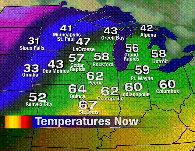 Dakota!


No comments:
Post a Comment