
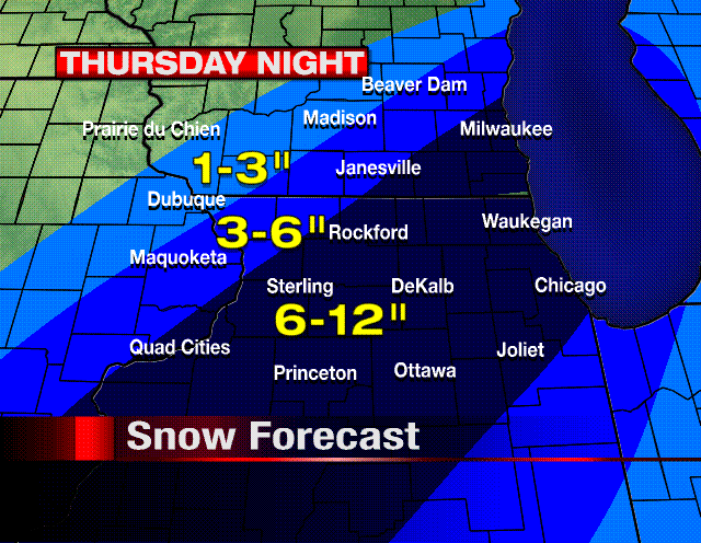
 The evening models are in and the consensus is not good for North-Central Illinois and southeastern Wisconsin. Heavy snow will affect the area beginning at 7pm Thursday and ending at 9am Friday. Snowfall totals will be highest 30 miles east and west of DeKalb where 6-12 inches is possible. 3-6 inches of snow is possible from Freeport to Galena. Locally higher amounts will be possible as the liquid precip will average around one inch.
In addition to heavy snow, winds in excess of 25mph will be possible Thursday night. Blizzard conditions will be possible. A Winter Storm Warning or Heavy Snow Warning will likely be hoisted by the NWS with their 4am Thursday update. Developing... -ERIC


4 comments:
That is what i have wanted to see all year long! thanks for the GREAT NEWS Eric! means a lot to all the snowmobiliers! haha Keep up the excellent snow forecasting for the REST of the snow year!
thats what i like to see!!!!!!!!!
It is very exciting to think that this might be our first major winter weather event... sorry to all the travelers who will be out and about. Unfortunately it is not here yet and things are always subject to not turn out the way we anticipate. I am keeping my fingers crossed for something good-- but I am convinced I live in giant, unlucky weather bubble. What have I heard it called?? Perhaps the Rockford curse or something. Here's hoping for good some good news tomorrow night! Lots of snow!
I'll take 2", enough to make some money plowing. Any more than that is a hassle.
Post a Comment