
 Thanksgiving was spectacular! High temperatures ranged from 55 in DeKalb to 63 in Moline today.
Things will change gradually. For the weekend we'll remain mild with temperatures in the 53-57° range. However, the Gulf of Mexico will be open for business late into the weekend and especially next week. This will allow more clouds to build into the area. So, while we're treated to plenty of warm air it won't look quite like it was on Thanksgiving.
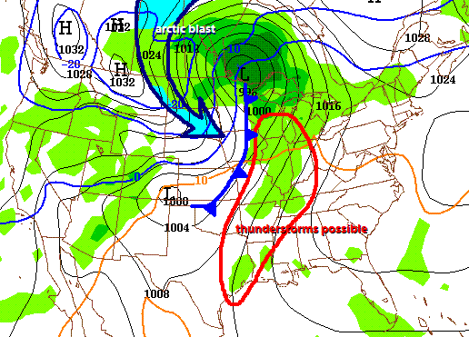 Beyond the weekend we've got a series of storm systems to contend with. The first brings some scattered showers for Monday. The second is colossal! Gusty south winds will allow temps up near 60° in most locations on Tuesday with some potentially big thunderstorms. The image to the left is the GFS computer model which brings a powerful front into the area on Tuesday afternoon. There could be a large area of potentially strong thunderstorms with a major surge of cold air behind...the likes of which we haven't seen this fall season. Temperatures in the NW Territories of Canada have been below zero during the daylight hours the past week. While it looks like this surge of Canadian air will be harsh, it doesn't look like it will last more than a week. For those of you who are jumping at the bit for snow, this one looks like a non-event. Precip will be winding down as the cold air surges in. Milder temperatures are forecast for most of the month of December. -ERIC


No comments:
Post a Comment