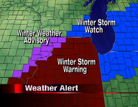
 Winter Storm Warnings were issued for the majority of northern Illinois early this morning while Winter Storm Watches remain for Rock and Walworth Counties and a Winter Weather Advisory for Stephenson, Jo Daviess, and Carroll Counties in Northwest Illinois starting tonight and lasting through midday Friday.
An area of low pressure is expected to develop and move through the Mississippi Valley late this afternoon and evening. As it does, copious amounts of moisture in the low levels of the atmosphere will accompany it allowing for snow showers to develop late this evening and overnight. There are a couple things to watch very closely as this storm continues to develop and move northeast. The track is still a little uncertain, even a day away, but computer models are still putting northern Illinois in the zone for some heavy snow amounts. Two: there is a little dry and warm air in the upper levels of the atmosphere. So as snow does begin, we could actually see a snow/sleet mix early in the evening before colder air filters into this storm and the air begins to moisten up. If we see a mix of sleet and snow initally, then snowfall amounts will be reduced a little througout the Stateline. As the system continues to track south of Chicago, more than likely heavier bands of snow will develop across the region which could produce amounts of 10" or more! Winds will also be very gusty from the northeast tonight so that could cause blowing and drifting snow along roads and sidewalks.
Bottom line, as heavier amounts of snow begin to fall roads could become slick through early morning. So if you have to travel, please use extreme caution. Eric and I will be here keeping a very close eye on the storm as it develops and moves in.


3 comments:
I just want a snow day. Thanks.
Can you arrange a snow day PLEASE!!!
I think it'll take around 6" for most schools to close...if we hit our target you can get those toboggons (sp?) ready!
Post a Comment