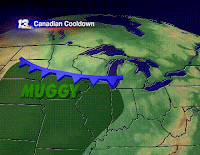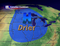
 That's right, those muggies (no relation to the Soggies, I would imagine) crept back into our neck of the woods today. Part of it was that enough Gulf moisture was close enough to be able to pool up to the cold front pretty quickly... and the other part is simply that it rained. Our weekend is quite salvageable, though, so don't fret! That cold front I mentioned is slipping southward, scooping out that humidity. With dry air moving in, our rain chance is completely leaving us for a couple of days. In fact, clouds will be few and far between until we get some of the fair weather variety Sunday afternoon.
We do have the possibility of fog overnight, though. With plenty of moisture at the ground, along with clearing skies and cooling temperatures, plus winds that should be rather light, there may very well be areas with reduced visibility later tonight and tomorrow morning. Those favored river valleys (it's easier to type than say, in case you caught the 6pm newscast) will have the best chance for having fog overnight. Lots of sunshine and otherwise dry air will evaporate the fog pretty quickly in the morning where it does develop, though.
Completely off-topic, there was a shower (maybe a thunderstorm) that produced some funnels and even a tornado (or tornadoes?) in central Iowa this evening. Some GREAT pictures can be found at http://mesonet.agron.iastate.edu/cases/080809/. Thanks to the central Iowa TV stations for passing their viewer photos on to the Iowa Environmental Mesonet, which hosts those photos. (Technically, it appears the tornado is actually what's known as a "landspout.") (Second parenthetical comment! - some of the pics really show you what the outflow from the rain can do to the tornado's structure... see if you can find them.)
4 comments:
Y'mean those cool pix where the condensation funnel trails off into a funny little ribbon?
Definitely way cool!
I'm guessing that the tornado is probably just about "history" when those ("ribbon") photos were snapped.
There can't possibly be much rotation or lift going on in the portion of the funnel where the "ribbon" effect appears.
I'm guessing that the "ribbon" is just remaining condensation (and possibly small debris?) that is still airborne as the tornado is rapidly falling apart.
Is that about right?
Since you mentioned it: what is the difference between a landspout (or waterspout) and a tornado?
I think I remember learning that a waterspout (or landspout) is a tornado, just not a very big one.
I thought it used to be believed that tornados "touched down" from the parent cloud, and "landspouts" (or "waterspouts") were thought not to "reach up" all the way to the cloud. But nowadays they believe that tornados "spin up" from the ground rather than "touching down" from the cloud, so the distinction between tornados and land/waterspouts kind of evaporated. (??)
Am I confused?
Since our weather will be wonderfully tranquil tomorrow, I'll devote tomorrow's entire blog post to your questions and any subsequent ones. (BTW, can you post a link to the pictures you're referring to - if you remember which they were?)
Hopefully you can withstand the suspense! :D
Some of the pix where the "ribbon" appears:
http://mesonet.agron.iastate.edu/cases/080809/clare_long_funnel_kcci/DSC_0192.JPG
http://mesonet.agron.iastate.edu/cases/080809/clare_funnel4_kcci/image001.jpg
http://mesonet.agron.iastate.edu/cases/080809/clare_funnel_kcci/tornado014.JPG
Geez, I don't know if I can stand the suspense. I can hardly stand the suspense just waiting for the regular news/weather to come on.
Let me just say for the record that I am already officially tired of the Olymics. How much longer are they going to pre-empt all other NBC programming? 10 days? Ugh.
In that type of tornado, what speed winds are there typically? Im guessing an EF-0, but I wasn't sure exactly how weak they are.
Post a Comment