 Some of the things that have gone through our minds the past few weeks is the fact that the 2005/2006 winter was the fifth warmest winter on record for the United States.
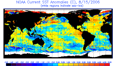
Next is the observance of a moderate El Nino setting up in the eastern Pacific Ocean. Notice a broad area of warmer than normal water (orange/red) tucked along the Central American coast. (click on the image to enlarge) These waters also sit over the equator tracking from the dateline eastward into the East Pacific. This set up is typical of El Nino autumns. A significant lack of tropical weather (storms and hurricanes) in these regions has
 allowed SST'S (sea-surface temperatures) to warm.
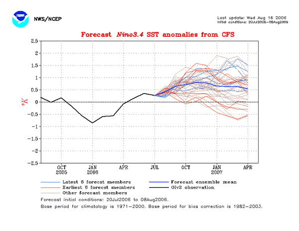
The next graph shows the forecast for the winter. Each line represents a weather model's output. The blue line is the mean of all of the models. This would lend support to the belief that an El Nino will be present through the 2006/2007 winter season.
Next thing to consider is the fact that we've already seen our first trace of snowfall for the season and October 2006's has given us temperatures -1.6°F below average (at the Chicago/Rockford Int'l Airport). Our average monthly temperature (up to October 16) has been 52.8°F compared to a normal of 54.4°F. During the El Nino winter of 1997/1998, much of the Midwest saw an unusually cold autumn followed by a very mild, dry winter. The similarities are too great to ignore.
The Official WREX-TV Winter Forecast for Northern Illinois/Southern Wisconsin is as follows...
November 2006: A few very generous snowfalls are expected. Temperatures will remain cooler than average (continued from October). Temperatures will average 2-6° below average with average precipitation.
December 2006: Near average precipitation is expected. Numerous snow events will be expected. A few very cold spells will be likely, especially early in the month with a slightly milder month expected overall.
January 2007: Below average precipitation is expected. Temperatures will be slightly colder during the first part of January, followed by milder temperatures late in the month. January's temperatures will likely average slightly higher than normal.
February 2007: Below average precipitation is expected. Temperatures will be remarkably milder.
March 2007: Below average precipitation is expected. Temperatures will be at or slightly above monthly averages.


No comments:
Post a Comment