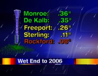
The big rainmaker that was moving towards us this weekend, ended up splitting in half. The heaviest precipitation fell to the northwest and southeast of us. Minneapolis saw some decent snow, while Indianapolis dealt with thunderstorms. We still saw a dreary and damp finish to 2006. December 31st rainfall totals are at left.
The next question is, when are we going to see some more snow? At this point, probably not for awhile. -ADAM
Sunday, December 31, 2006
Saturday, December 30, 2006
Travel Delays
While the beginning of December came in on a snowy and cold note, the end of the month will be much different...wet and very mild!
The past major storm systems we've had move through have come from the Pacific Northwest which means they don't have many ties to the cold, arctic air....unless you're in the Plains and Rockies. The current system now moving through the south will move closer to the Stateline through the end of the weekend. Cold air has been moving in behind it and once again caused headaches for folks living in Colorado, New Mexico, Kansas, and Nebraska. While they saw blizzard conditions, we will be seeing rain. However, if your holiday plans take you into Wisconsin, Minnesota, or the Dakota's through Sunday you will more than likely run into some travel problems. Snow and possibly blowing snow will be flying through the Dakota's and Minnesota while rain will be falling here. So if you have any big New Year's plans, just make sure that pay extra attention while behind the wheel.
Friday, December 29, 2006
Weekend Plans
If you have some outdoor plans for this 3 day weekend, here's the break down: The majority of the daytime hours on Saturday should remain dry, other than a sprinkle or two. Our chances for soaking rains will increase greatly late Saturday night and into Sunday. Scattered showers will continue on into the first day of 2007. By Monday night, this storm system should be through with us and we should see drier weather move in for the first week of January.
Enjoy your Weekend. -ADAM
One Last Roar!
2006 has one last roar in it, at least in the weather world. A strong area of spin has developed near the panhandle of Texas. This approaching storm is dumping feet of snow on portions of Colorado, and has even spawned a few tornadoes across central Texas. For the latest road conditions in Colorado, click here.
We won't see any severe weather, but we should see some soaking rains starting early Sunday morning. -ADAM
Thursday, December 28, 2006
Hurricane Force Winds
While we sometimes think the winds can gust around here, take a look at some of the wind gusts that were reported yesterday, Wednesday, in California and Nevada:
Alpine Meadows, CA 167 MPH
Slide Mountain (Mount Rose), NV 135 MPH
Mammoth, CA 120 MPH
Mogul, NV 92 MPH
Burns Canyon Raws, CA 69 MPH
The storm system that was responsible for those damaging winds will be the same one that will move into the Stateline this weekend and give us a rainy end to 2006. We won't see winds that strong, but they could get a little gusty for the weekend.
Wednesday, December 27, 2006
Ending with a Bang!
2006 looks like it may be ending with a bang. Many models are predicting at least an inch of liquid precipitation before this weekend is over. Some, such as the picture at left, are plotting out over an inch and a half of rainfall. This storm system is just starting to come together right now over the southwestern corner of the country. It looks to track directly toward the stateline. In this scenario, we will stay in the warm sector of the storm for the majority of the time. This means that our precipitation (sorry snow lovers) will be mainly falling as rain. In my opinion, I'm calling a party foul on Mother Nature for all New Year's Eve celebrations. -ADAM
Tuesday, December 26, 2006
This is Winter?
It sure doesn't feel or look like winter around here. Bare ground and warm temperatures have been a staple in our weather for the past two and a half weeks. Our weather pattern doesn't look like it will cool off anytime in the near future either. High temperatures will continue to rise to above average levels into the new year. The picture at left is the closest you will get to a snowman for quite awhile! -ADAM
Christmas Torndoes for Florida
While many of us were celebrating the holidays with family and friends Christmas, some residents in Florida were cleaning up after severe weather ripped through the southern states. Wind, rain, and even tornadoes were reported from early in the morning to late at night. At least two tornadoes have been confirmed and over five and a half inches of rain was reported at the Tallahassee Regional Airport. WJXT-TV has more on the devastating storms.
Saturday, December 23, 2006
Rainy End to the Week
While some parts of the U.S. were dealing with feet of snow, Northern Illinois and Southern Wisconsin residents were dealing with a good deal of rain this past week. While it was dry earlier in the week, a storm system dumped almost an inch and a half Wednesday through Friday. The holiday weekend will remain dry, however we may see a few snow flurries/showers just in time for Christmas. It may not be enough to "officially" call it a White Christmas...but just enough to put you in the spirit.
Thursday, December 21, 2006
Veteran Meteorologist Passes Away
Jim Giles was a longtime Meteorologist for KOTV in Tulsa, Oklahoma. Jim was hired as the Chief Meteorologist for the station in 1981 and kept many Oklahomans out of danger with countless severe weather alerts. Read more on Jim Giles' career by clicking here.
Colorado Blizzard
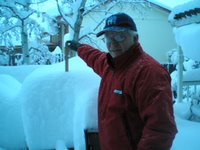
Take a look at these pictures taken by Ron Harrell of Morrison, Colorado. He received 34 inches of snow! Not only did it take a half hour to find the car in his front driveway, look at the blue 4X4 that got stuck in the street! :-)
It sounds like he's got good spirits! "I know this might not seem like a big deal to some of you, but for a flat-lander like me who moved to Colorado 15 years ago from Louisiana, this is a big deal. We usually get 4-6 inches of snow at any one time, so this storm has pretty much paralyzed the entire city and metro area."
For those of you trying to get on a United flight from Rockford: The Denver Int'l Airport is expected to open at noon Friday. -ERIC
Formal Introduction
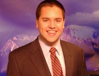
My name is Adam Painter, and I am the newest member of the weather team at WREX. The picture at left was taken at my previous job. If the mountains don't give it away, I spent the past two years working as the morning meteorologist at the NBC affiliate of KECI in Missoula, Montana. I will be the morning meteorologist here at WREX. That way Candy can sleep in like a normal person...
I grew up in Mound, Minnesota, which is a western suburb of Minneapolis. From there I studied and got my degree in meteorology at Iowa State University in Ames, Iowa. As you can see, I am a Midwesterner at heart.
I am not a fan of idle time, so to keep myself busy I play pick-up basketball games at the local YMCA, ski the hills of the Midwest, and rip divots out of local golf courses during the summer.
I am very excited to be here in Rockford, and am happy to join a strong and experienced team. If you have any questions for me, don't hesitate to drop me a line at apainter@wrex.com
Adam
Wednesday, December 20, 2006
Where should the thermometer be?
No, I'm not talking about the average high and low temperatures for the first day of winter!
Richard Martinson of Rockton asks: "I need to know where the best location would be for that outdoor temperature sensor. My thought is to place the sensor on the top post of my deck off the west side of my house. This would make the sensor very exposed, about 8 feet from the house and 10 feet in the air, which brings up the question of lots of direct sunlight. Is this the best location for a temperature sensor?
Official National Weather Service thermometers are housed in "cotton region shelters" like the one shown to the left. To ensure proper temperature measurement thermometers have to be placed out of direct sunlight, ten feet above the ground. So, to answer your question Richard, as long as your thermometer is out of the sun, the deck seems to be a pretty good spot! -ERIC
p.s. Send your weather question to us!
December's Snow Storm Could Pay Dividends for Farmers
PEORIA, Ill. (AP) -- Wintry clouds that dumped a sheet of ice and more than a foot of snow across parts of Illinois earlier this month could have a silver lining for the state's grain farmers, officials said Monday.
Weather and farm officials say the already melted ice and snow now is seeping deep into fields, providing a moist savings account for next year's corn and soybean crops. (Read the full story here.) -ERIC
Denver Blizzard
10:25pm-Snowfall amounts have ranged from 8 to 14 inches so far tonight! Snow will continue to fall across Northeastern Colorado tonight into early tomorrow where some areas could see 16-26 inches! The National Weather Service says that some areas could have drifts up to six feet!
3:15pm-Interstate 25 north of Denver is closed this afternoon (Wednesday) because of heavy snow and drifting. (More road conditions)
The Denver International Airport has also been closed due to snow. (More Airport closures) KUSA-TV reports that passengers have been stranded on grounded aircraft since this morning. Click here for their live streaming coverage.
Some areas along the front range of the Rockies may see more than 16" of snowfall. While I don't think we need a storm like this one, it makes me a little jealous of those out west with a sure-bet for a white Christmas.
Occasionally I will surf the AM radio dial during my evening dinner-break. On most days, I can receive 850AM KOA out of Denver. It will be very interesting to tune in tonight to see what kinds of reports come in. I will also have the latest tonight on 13News Ten at Ten. -ERIC
New Tropical Storm?
Well, sort of. The new storm occurred back in July. The National Hurricane Center ran a post-season analysis confirming the thought that the system became a warm-cored tropical storm. The storm formed about 240 miles southeast of Nantucket, Massachusetts on July 17 from the remains of a cold front that had pushed off the East Coast on July 13. At its strongest, the unnamed storm had sustained winds of 50 miles per hour. It quickly moved northeastward into much colder waters, which killed the storm 24 hours later.
For an archive of the track of this year's tropical storms and hurricanes, click here.
-ADAM
For an archive of the track of this year's tropical storms and hurricanes, click here.
-ADAM
Tuesday, December 19, 2006
Snowstorm for the Front Range!
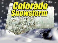
A major blizzard will grip parts of Nebraska, Kansas, and Colorado on Wednesday. The Denver metro could receive upwards of 16 inches of snow with higher amounts from DIA northeast toward Sterling, CO and North Platte, NE. Blowing and drifting will bring travel to a stand still.
For us, the threat is rain. As 13Microcast shows, we've got a chance of 3/4" of liquid precipitation. (If temperatures were 12° cooler we would have six inches of snow.) The rain will begin late Wednesday night into Thursday. -ERIC
Year-Round Golfing!
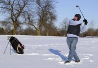
LEMONT, Ill. - For most golfers, the year's first snowstorm means it's time to put the clubs away. Or book a flight to California or Florida.
But for a small group of friends in suburban Chicago it means putting on longjohns, sweat shirts, sweaters, boots, jackets, wool hats and gloves. And, oh yeah, breaking out the snow shoes.
For about two decades they've been playing at Cog Hill Golf & Country Club through whatever weather is thrown at them (read the full story).Travel Nightmare!
If you're about to pack the kids and Aunt Edna into the family truckster for the Christmas holiday, you had better beware of the weather to our west! As of Tuesday afternoon, Blizzard Warnings were in effect for the western third of Nebraska while Storm Warnings were hoisted for most of Colorado. Interstate 90 could be hazardous from Minnesota westward. Interstate 80 will be icy west of Omaha, Nebraska. Interstate 70 will be very treacherous in western Kansas. Follow these links for the latest National Weather Service forecast:
Denver, Colorado
Pueblo-Colorado Springs, Colorado
Amarillo, Texas
Albuquerque, New Mexico
Cheyenne, Wyoming
North Platte, Nebraska
Sioux City, Iowa
Sioux Falls, South Dakota
Rockford, Illinois
Denver, Colorado
Pueblo-Colorado Springs, Colorado
Amarillo, Texas
Albuquerque, New Mexico
Cheyenne, Wyoming
North Platte, Nebraska
Sioux City, Iowa
Sioux Falls, South Dakota
Rockford, Illinois
Monday, December 18, 2006
"An Inconvenient Truth"
Over the weekend, a friend of mine and I sat down to watch "An Inconvenient Truth," the documentary by Al Gore on global warming. He said that I needed to watch it so I could debunk the theories that were proclaimed in the movie. It made sense to me...If you're watching a documentary on global warming, it's probably good to have a Meteorologist on hand.
I had control of the remote control (in order to press the pause button at a moment's notice if I saw something that I didn't think was true).
I fould the movie to be pretty self-explanatory (although I don't really know how the 2000 election debacle had anything to do with global warming). One of the big criticisms I have of the movie is the fact that almost every graph has a title on the x-axis (along the bottom) but not on the y-axis (on the left side). For instance, many of the graphs showed temperature trends. As temperatures increase the line steadily moves up. However, the left side of the graph isn't labeled...so it's up to your interpretation as to the significance of the warmth.
Speaking of warmth, I decided to go back and look at the data for Rockford, Illinois temperatures! Take a look at the average temperature (in Fahrenheit) for the past several decades.
2000-2006: 49.15°
1990-1999: 48.48°
1980-1989: 48.04°
1970-1979: 47.61°
1960-1969: 47.48°
1950-1959: 48.43°
1940-1949: 49.57° (years 1946 and 1948 were missing data and thus not averaged)
1930-1939: 50.20°
1920-1929: 44.17°
1910-1919: 47.87°
1906-1909: 48.75°
It is a fact that we've seen increased warming since the 1950s. However, our warmest years on record in Rockford were in 1921 and 1931 when the year's average temperature was 52.8°. It remains to be seen whether or not we'll eclipse those records, but if you look at the trend it seems possible within the next decade.
I apologize for the tangent...Now back to the movie! There was a chapter that dealt with the vast areas of the Antartic Ice Shelf calving off into the ocean. While there has been a major melting of the ice caps in Antartica, (I don't think anyone can deny that) the documentary didn't tell us how much snowfall is accumulating each year...it only pointed out how much ice has left the continent.
So, after watching the two hour documentary I pushed the pause button twice. I was actually quite surprised at all of the things that I could agree with. I am proud to admit I am highly skeptical of Al Gore (Didn't he invent the internet?). And to be fair, I am highly skeptical about almost everything. But we need to find the bottom line...or the point to this way-too-long-blog-entry.
We can't forget that the Upper Midwest was underneath a thousand feet of ice 13,000 years ago. When those glaciers began to melt, we could have said that global warming officially began. We know the earth's atmosphere is changing...and warming up. To what extent humans are altering this change is up for debate, but it seems to be taking place.
One thing I've been arguing is: "Instead of spending $320Billion dollars fighting a war with Iraq, we should have invested the money in an infrastructure that promotes hydrogen fuel-cell cars. If we didn't have a dependence on foreign oil, the crazies over there wouldn't have a pot to .... in and the U.S. wouldn't be adding millions of pounds of pollutants to the atmosphere each second."
Just my personal thought.
Eric Sorensen
Chief Meteorologist
WREX-TV
I had control of the remote control (in order to press the pause button at a moment's notice if I saw something that I didn't think was true).
I fould the movie to be pretty self-explanatory (although I don't really know how the 2000 election debacle had anything to do with global warming). One of the big criticisms I have of the movie is the fact that almost every graph has a title on the x-axis (along the bottom) but not on the y-axis (on the left side). For instance, many of the graphs showed temperature trends. As temperatures increase the line steadily moves up. However, the left side of the graph isn't labeled...so it's up to your interpretation as to the significance of the warmth.
Speaking of warmth, I decided to go back and look at the data for Rockford, Illinois temperatures! Take a look at the average temperature (in Fahrenheit) for the past several decades.
2000-2006: 49.15°
1990-1999: 48.48°
1980-1989: 48.04°
1970-1979: 47.61°
1960-1969: 47.48°
1950-1959: 48.43°
1940-1949: 49.57° (years 1946 and 1948 were missing data and thus not averaged)
1930-1939: 50.20°
1920-1929: 44.17°
1910-1919: 47.87°
1906-1909: 48.75°
It is a fact that we've seen increased warming since the 1950s. However, our warmest years on record in Rockford were in 1921 and 1931 when the year's average temperature was 52.8°. It remains to be seen whether or not we'll eclipse those records, but if you look at the trend it seems possible within the next decade.
I apologize for the tangent...Now back to the movie! There was a chapter that dealt with the vast areas of the Antartic Ice Shelf calving off into the ocean. While there has been a major melting of the ice caps in Antartica, (I don't think anyone can deny that) the documentary didn't tell us how much snowfall is accumulating each year...it only pointed out how much ice has left the continent.
So, after watching the two hour documentary I pushed the pause button twice. I was actually quite surprised at all of the things that I could agree with. I am proud to admit I am highly skeptical of Al Gore (Didn't he invent the internet?). And to be fair, I am highly skeptical about almost everything. But we need to find the bottom line...or the point to this way-too-long-blog-entry.
We can't forget that the Upper Midwest was underneath a thousand feet of ice 13,000 years ago. When those glaciers began to melt, we could have said that global warming officially began. We know the earth's atmosphere is changing...and warming up. To what extent humans are altering this change is up for debate, but it seems to be taking place.
One thing I've been arguing is: "Instead of spending $320Billion dollars fighting a war with Iraq, we should have invested the money in an infrastructure that promotes hydrogen fuel-cell cars. If we didn't have a dependence on foreign oil, the crazies over there wouldn't have a pot to .... in and the U.S. wouldn't be adding millions of pounds of pollutants to the atmosphere each second."
Just my personal thought.
Eric Sorensen
Chief Meteorologist
WREX-TV
State of Science 2006
On Monday, the Associated Press released it's "State of Science 2006" which details some of the biggest science stories of the year. To read the entire story, click here. -ERIC
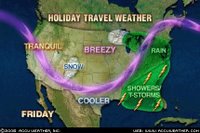
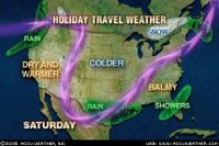
Holiday Travel Weather
If you are planning on getting the family truckster on the highway later this week, you should be in good shape. While we will have a midweek system providing some rain and snow to the country's mid-section, much of the weekend will be dry.
Take a closer look at these weather maps (courtesy of accuweather.com) for your travel planning weather.
Friday, December 15, 2006
More Northern Lights?
Many of you are wondering when we'll see the Northern Lights again. Keep tabs on the image that is located in the "Active Night for Skywatchers" article. I should have captured last night's image so we can compare, but the red area (+10) was almost down to the US-Canada border. That map can act like a little "forecast" for future auroras. While there could be a few displays (way away from the city lights) the chances of a repeat of last night are pretty slim for a while. -ERIC
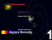
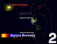
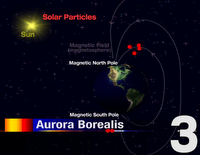
How does the Aurora Borealis work?
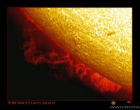
(figure 1) On Wednesday, scientists observed an unusually strong solar flare. Solar particles began traveling 1,000 miles per second toward earth's magnetic field.
(figure 2) The earth's magnetic field, or magnetosphere, attracts the solar particles. The particles are put together much like beads are threaded on a wire.
(figure 3) The particles accelerate as they travel down the magnetic field lines. The particles collide with the atoms and molecules of the upper atmosphere where the magnetic field lines reach down to the surface of the earth (near the magnetic north and south poles).
(figure 4) When the particles from the magnetosphere collide with the atoms and molecules in the earth's upper atmosphere (over the north and south poles) atoms of oxygen and nitrogen release their energy in the form of light. This is the light that we see from the ground...the aurora borealis!
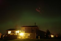
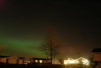
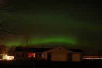
Viewer Pictures from Thursday Night
Thursday, December 14, 2006
Active Night for Skywatchers!
I've received numerous calls and E-Mails regarding tonight's northern lights (aurora borealis). I sent out a special 13YourCast e-mail with the hopes of catching some of you. I hope you got a chance to view them. The image to the left shows the present auroral activity. (click to enlarge) You can see the bright red over Hudson Bay tonight indicating a high level of auroras! While the sights can be seen over Northern Illinois, it likely isn't viewable south of St. Louis!
If you have any pictures of tonight's display, please send them to me! esorensen@wrex.com
In addition, on my little trek through the country this evening, I saw many shooting stars that were brightly lit all the way down to the ground. There are still so many because the geominid meteor shower peaked last night. In fact, a micro-meteorite struck the Space Shuttle early this morning while the astronauts slept. For more info on that, click here. -ERIC
Wednesday, December 13, 2006
Severe Space Storm Headed to Earth
While the weather in the Midwest will be quiet through the weekend, the weather in space will be flaring up. Space.com reports that a major flare erupted from the sun Tuesday night. This solar flare could impact the earth Thursday by disrupting power grids and causing communication systems to malfunction. Lead forecaster at the NOAA Space Environment Center says "We're looking for very strong, severe geomagnetic storming" to begin mid-day Thursday. To read the full story, click here. -ERIC
Record Breaking Year
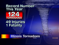
Even though the Rockford area saw a fairly tranquil severe weather season in 2006, that did not hold true for the entire state. Southern Illinois was especially busy with tornadic activity. The three significant tornado outbreaks ocurred in March and April. On March 12th, there were 12 tornadoes near Springfield. On April 2nd, there were 36 tornadoes in St. Clair County. Lastly on Easter Sunday (April 16th), there were 14 tornadoes spread across the eastern half of the state. Here's a look at the Public Information Statement that was released today! -Adam
Record number of tornadoes in Illinois during 2006:
A total of 124 tornadoes were reported within the state so far in 2006...breaking the record of 120 tornadoes that occurred in 2003. The hardest hit areas were in Central and Southwest Illinois where 106 tornadoes were reported. The record number of tornadoes resulted in 1 fatality and 49 injuries.
Take a look at how many tornadoes touched down in Illinois each month:
January: 1
February: 1
March: 21
April: 60
May: 17
June: 2
July: 16
August: 0
September: 6
October: 0
November: 0
December: 0 (through the 12th)
Fujita Scale:
F0 (weak): 73
F1 (weak): 35
F2 (strong): 15
F3 (strong): 1
F4 (violent): 0
F5 (violent): 0
Tuesday, December 12, 2006
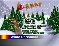
What is our chance of a white Christmas?
Many of you have asked us that question over the past few days and finally the models are hinting at something!
What we know for sure is the weather pattern will remain off the Pacific for the next week. This will keep us rather wet and very mild. In fact now that we've melted off all of the snow we could be above 50° late in the work week.
The GFS computer model advances some pretty harsh Canadian air into the upper plains states by December 22nd. This will allow temperatures to support snow. Whether or not there'll be a white Christmas (at least one inch on the ground) depends on the amount of moisture scooped up from the Gulf. That remains to be seen now, so I'll go with a 1 in 4 chance as of today. Stay tuned! -ERIC
What Does this Winter Hold for Us?
The Climate Prediction Center has come out with an update to the El Nino situation that is currently developing in the Eastern Pacific. As it looks right now, the current forecast is right on track for the strengthening of El Nino through the winter and into Spring. So what does that mean for us in terms of our winter? Well, looking back at previous El Nino seasons, winters tended to be a little milder than average and precipitation fell below average. As far as snow, there were only a few years that snowfall totals were more than the average: 1963 and 1987! Every other El Nino year, snowfall amounts were below normal! Typically the effects of El Nino aren't felt until later in the season, but this could be very interesting to see how Rockford will pan out. Read more about this unfolding event from The National Weather Service.
Dense Fog All Around!
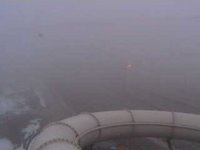
This is a picture of Highway 20 right by I-90 looking east from our Magic Waters Cam at 8am! You can barely even see the road! Fog has become very dense across the Stateline this morning and will continue to persist through this morning and afternoon. Visibilities in Rockford have been reduced to less than a tenth of a mile and near zero miles in some other spots. As a result, Dense Fog Advisories have been issued until 10am this morning for all of Northern Illinois!
Please be careful when driving this morning. Driving conditions can change rapidly without any warning!
Monday, December 11, 2006
Dense Fog Advisories!
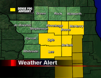
Watch out there for the dense fog! The National Weather Service has issued a Dense Fog Advisory for the counties shaded in yellow (as of 6:00pm). To check the status of visibilities in your area, click here.
Be safe tonight! -ERIC
Sunday, December 10, 2006
Death to all Snowmen?
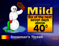
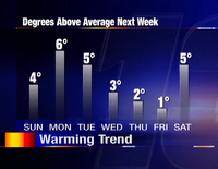
I know the title sounds rather bleak, but it's true! We've got quite the warming trend in the works this week...the likes of which will probably melt most of the snow. If you're an avid snowmobiler, get out there for the next few days because the warm weather will be above 40° for six of the next seven days. If you're a snowman, you better shed the scarf now! -ERIC
Rocket Launch May Surprise Those on East Coast
On Monday December 11th, around 7:00 a.m. EST (The actual launch window extends for several hours beyond 7 a.m.) a Minotaur-I rocket is scheduled to be launched from Wallops Island, Virginia. This rocket will rapidly ascend to an altitude of 255-miles over the Atlanticin less than 10-minutes, to deploy two research satellites. From the Greater New York Area, the long contrails that the rocket leaves in its wake should be visible low toward the southern and southeast parts of the sky. Based on similar launchings from Vandenberg Air Force Base in California, the contrails may become weirdly twisted and contorted (due to high altitude winds) and may attract the attention of the general public -- especially since the launch is due to take place in the middle of a Monday morning rush hour! Because the launch will occur just prior to sunrise (in a twilight sky) visibility along much of the US East Coast is anticipated. Unfortunately, if the launch takes place well after sunrise, little or none of it may be seen. For complete sighting details, including links to the latest launch updates aswell as a live webcast of the liftoff from Wallops Island go to: http://tinyurl.com/yl6d3c -ERIC
New Report: Cows contribute more Carbon Dioxide than Automobiles
I wouldn't have thought Harmilda the cow could be blamed for global warming, but it appears some science now proves it! A recent United Nations report has identified the world's rapidly growing herds of cattle as the greatest threat to the climate, forests and wildlife!
An article recently published by "The Independent" has all of the details on how the flatulance of cows causes acid rain, the manure pollutes streams and rivers, and the increasing deforestation to provide farmland is increasing our carbon dioxide levels. -ERIC
Your thoughts?
An article recently published by "The Independent" has all of the details on how the flatulance of cows causes acid rain, the manure pollutes streams and rivers, and the increasing deforestation to provide farmland is increasing our carbon dioxide levels. -ERIC
Your thoughts?
Saturday, December 09, 2006
Going Up From Here
Saturday's highs were right where we're supposed to be for the beginning of December! And temperatures will only continue to rise from there. After we've been dealing with the cold weather over the Stateline for the past week, the upper 30s and even lower 40s will make a come back.
However, with the warming temperatures clouds will begin to increase along with fog Sunday through Tuesday. The snow will continue to melt during the day, but it will be a slow melting trend because at night temperatures will still fall just below freezing.
Friday, December 08, 2006
2007 Hurricane Prediction
Colorado State University professor Dr. William Gray released his forecast for the 2007 hurricane season today. He predicts an above-average season with 14 named storms next year, including three major hurricanes and four other hurricanes. Read the full story here.
The Associated Press photo to the left shows the "pirate plank" walk which marked the end of the 2006 Atlantic hurricane season in Key West, Florida. The poor guy dressed as a hurricane was tossed into the drink...but it was a nice time to celebrate as the United States didn't see one hurricane make a landfall.
By the way: Dr. Gray predicted an 81% chance that at least one major hurricane would make U.S. landfall in 2006. Trust me, it's hard enough forecasting weather for seven days out! I would hate to make a forecast for a whole year. -ERIC
Thursday, December 07, 2006
Coldest December Start in 30 Years!
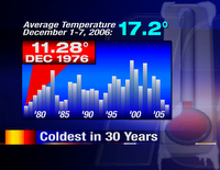
If you think December has been cold so far, you are absolutely right! As of December 7th our average temperature was 17.2°F. Typically we see an average of 29.0° during the first week of December. Looking back at the historical records for Rockford, we haven't seen a colder start to December since December 1976!
Let's hope things chance for December's second week. -ERIC
Subscribe to:
Posts (Atom)