Tuesday, October 31, 2006

The End to a Very Cold October

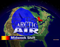
October 2006 will be remembered as a very chilly month here in Northern Illinois and Southern Wisconsin. In fact, temperatures were more than 3° below average for the month! We saw a nice warm stretch during the first week of the month, but temperatures on the ninth took a nosedive and we never recovered. Of the 31 days of the month, 7 were above normal with 23 below normal. On one day we had an observed high that equalled the average high. The warmest temperature of the month occurred on October 2nd when we were 86°. The coldest temperature occurred on the morning of October 25th with a temperature of 25°. 3.52 inches of rain and snow fell at the Chicago/Rockford International Airport during the month. That's over an inch above average. -ERIC

As we reported in mid-October, here's the official 2006/2007 WREX-TV Winter Forecast:

November 2006: A few very generous snowfalls are expected. Temperatures will remain cooler than average (continued from October). Temperatures will average 2-6° below average with average precipitation.
December 2006: Near average precipitation is expected. Numerous snow events will be expected. A few very cold spells will be likely, especially early in the month with a slightly milder month expected overall.
January 2007: Below average precipitation is expected. Temperatures will be slightly colder during the first part of January, followed by milder temperatures late in the month. January's temperatures will likely average slightly higher than normal.
February 2007: Below average precipitation is expected. Temperatures will be remarkably milder.
March 2007: Below average precipitation is expected. Temperatures will be at or slightly above monthly averages.

Dry and Windy!

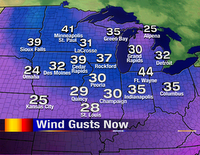
With the passage of a cold front late last night, the atmosphere has really dried out! That combined with very gusty winds this afternoon will not make it a good day to burn any leaves you may have raked up this past weekend. Plus, I'm sure they have all blown away by now :-)

With such low levels of humidity in the air and strong winds, it would make it very easy for a simple fire to turn out of control quickly. The good news is, if your leaves haven't blown away yet, the winds will slowly subside over the next couple of days. It will still be a little breezy Wednesday afternoon so you might want to wait until the end of the week to do any burning!

Monday, October 30, 2006

Trick or Treat Weather

Happy Halloween to you! Hopefully your day brings more treats than tricks! For all of our little ghosts and goblins, Mother Nature's going to give us dry weather...but plenty cold! Growing up in Rockford, I remember many Halloweens and most were cold! At trick-or-treat time we'll see temperatures around 40°.

If you're looking for Rockford area trick-or-treat times, I've got that for you!

Roscoe: 5-8:00pm
Winnebago: 5-8:00pm
Rockton: 5-8:00pm
Rockford: 5:30-7:30pm
Freeport: 5-7:30pm
Cherry Valley: 5:30-7:30pm
Machesney Park: 5-8pm
Loves Park: 5-8 pm
Belvidere: 4-8pm

What was your favorite costume as a kid? -ERIC

What is DST and why do we use it?

How many of you enjoy the longer days in the summer and the extra hour of sleep in the fall? I know I sure do! But why do we "Spring Forward" and "Fall Back?" Well, I did some research and found some interesting articles. Check this one out!

Another thing? Daylight Saving Time has been extended for one extra month, starting next year! Read more about it! -CANDY

Saturday, October 28, 2006

Special treat for you skywatchers!

The SWAN comet has been seen streaking across the night sky this past week! Unfortunately, those with high-powered telescopes will have the best sight but some may see it with the naked eye! Look about 45° up in the sky to the west-northwest. Click on this sky-map and print it for your use out in the field. Let me know if you get any glimpses of the SWAN comet. Leave a comment or send me an E-Mail! -ERIC

No severe threat with powerful cold front

As temperatures on Monday will surge near 70° for much of the Midwest, a powerful cold front looms to our northwest.

One thing is different between this cold front and many spring-time fronts. For one, during the spring time, cold fronts don't usually make it far enough south to stop the moisture flow off the Gulf of Mexico. A cold front did just that on Friday...one that was strong enough to produce a damaging tornado in the panhandle of Florida. Over the weekend, high pressure over middle Tennessee will allow dry, southwest winds to heat us up before our strong front arrives late Monday night.

This type of frontal passage is typical for October/November in the Upper Midwest. Because we're in such a progressive weather pattern, systems are too quick to move through before the atmosphere can charge itself up. Severe weather is not possible with the front Monday night...and with such dry low-mid levels of the atmosphere, I'll keep rain chances out as well! -ERIC

Friday, October 27, 2006

Clouds will break...Winds will howl!

Another day with cloudy skies here in Rockford...another dismal look at the clouds through our 13Skywatch cameras. Today was the 13th day of cloudy skies just this month! Our cloudy weather pattern will change tomorrow as a moisture-starved front pulls through early Saturday morning. While we're expecting more sunshine, the winds will most definitely howl! For Northern Illinois and Southern Wisconsin winds are expected to gust near 35mph for much of the day. Wind Advisories have been posted for much of Northern Indiana with High Wind Warnings in Ohio and Pennsylvania.

Hold onto the fedora! -ERIC

Bring the garden indoors!

Autumn has sure made a firm grip on the Upper Midwest. However, think again if you think the growing season is over. Surely, you've seen the billboards across town about "Hydroponics" offering a pesticide-free, indoor growing environment. But for the beginner, think small! Many plants such as peppermint, chives, and rosemary will thrive indoors during the winter months, so long as they have some adequate sunshine. You can purchase these plants at area greenhouses and home centers, even this late in the season. I found a great article from the DIY Network on growing plants during the colder months. Check it out!

If you'd like to try something a little more challenging, you can purchase the supplies to create your "indoor garden." Hydroponics is increasing in popularity. I, for one, don't have much of a green thumb (unless my green pen explodes in my hand) but it may just be the perfect hobby as winter approaches. Do you move your veggies indoors for the winter? Post a comment! -ERIC

Thursday, October 26, 2006

Raging California Wildfires

A fast spreading fire took the life of four firefighters in Southern California on Thursday. Nearly 200 people were told to evacuate near Palm Springs as Santa Ana winds fanned the fire. Investigators say that an arsonist started the fire that has burned over 10,000 acres of land.

Click here to learn more about how Santa Ana winds work. Click on the satellite image to see the huge smoke plume. Amazing! -ERIC

Things are looking up!

Don't get too down because we're back in the 40s over the next couple of days. Things are definitely looking up by the first part of next week. It'll warm up for nearly all areas of the Upper Midwest!

Once we can get rid of this pesky storm system that is to our south, the skies will begin to clear once again late on Saturday and Sunday. By Monday we've got a shot at 60 degrees! However, it does look like it is going to be a short-lived warm up because by the time next Wednesday rolls around, temperatures could fall back into the upper 40s. The treat comes before the trick! -CANDY

Wednesday, October 25, 2006

Rocky Mountain Snow!

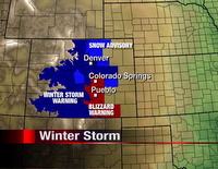
Quite a winter storm is shaping up for high plains of Colorado! Many locations along I-25 are under Winter Storm Warnings and Blizzard Warnings for Thursday. While most locations were in the middle to upper 50s on Wednesday, temperatures will crash. An area of low pressure will rapidly deepen (Meteorologists call this event a "bomb"). The "bombing" low will cause winds to gust near 50 miles per hour over the front-range of the Rockies. Denver could see near six inches of snow with some areas around Colo. Springs and Pueblo near a foot!

For more information, check out our affiliate websites www.9news.com and www.koaa.com.

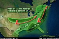
For us, we'll see only rain...but more importantly, only a little rain! The current storm track takes the powerful low from Oklahoma to Ohio by Friday. (Image courtesy of Accuweather.com) Northern Illinois/Southern Wisconsin will be on the northern fringes. While quite a thick deck of clouds is expected, rainfall will likely only add up to an 1/8 of an inch here. Some areas downstate could receive in excess of an inch.

With this system tracking south, it'll likely allow us to clear out a little bit over the weekend. It'll still be blustery and cool on Saturday, but Sunday will feature quite a bit of sunshine! -ERIC

Winds of Change

It was another chilly morning with temperatures once again starting off in the lower and middle 20s! But today we'll see temperatures in the lower 50s versus the middle 40s like we did yesterday. The reason...wind direction!

Even though there was ample sunshine on Tuesday, winds were coming in from the west/northwest. This really doesn't do us any good if we want to see warm (or semi-warm) temperatures this time of year. Today, however, winds have been a little breezy from the south/southeast and so as a result, temperatures will be able to make it into the lower 50s! But don't get too use to those southerly winds. Low pressure will move to the south of us and bring an increase in the cloud cover and a chance for rain late Wednesday night and into Thursday.

So get out and enjoy the sunshine while it lasts this afternoon! -CANDICE

Tuesday, October 24, 2006

Brighter Mornings Ahead!

If you're an early-riser you don't need me to tell you that it's pretty dark in the mornings nowadays! In fact, the sun rose today at 7:20am. By the time we get to Saturday, we'll lose a few more minutes of light. Look for a sunrise at 7:24. I looked through the official sunrise records for Rockford and realized the latest sunrise of the year occurs right around New Year's when the sun rises at 7:25am...only a minute later than Saturday! Click on this link to see the sunrise/sunset times for any city in the nation, for any date.

Besides getting an extra hour of sleep this weekend, what's another good thing about turning the clocks back Saturday night? Brigher mornings next week! Let's just hope the clouds will go away so we can actually see one! -ERIC

Frosty Morning!

It was a very chilly start for Stateline residents this morning. With clearing skies and light winds overnight, it was very easy for temperatures to fall into the low and mid 20s this morning. Wind chill values were even in the teens in some spots!

The last time we saw temperatures start off this chilly was back on the 15th of October, when the mercury dropped to 26 degrees. Thankfully we were no where near the record low this morning.... 18 degrees set back in 1981. With such a chilly start this morning, it's going to be hard to get temperatures to warm up past the mid to upper 40s this afternoon.- CANDY

Monday, October 23, 2006

Cosmic Rays Linked to Global Warming? Details tonight at ten!

No, I'm not talking about this one on the air... but I wish I could take a poll on what you think of this!

An article by LiveScience Magazine today reported that the earth's warming trend might be caused by a decrease of starlight. I admit, I am not an expert on cosmic rays, but it seems a little far-fetched to me.

I have heard many theories on global warming, but this one's new to me. Read the article, but don't forget to comment on this one! -ES

Blame it on El Nino?

I've mentioned before how this autumn season compares to the 1997/1998 El Nino. (El Nino winters bring us milder, drier weather.) But looking at the similarities between this year and 1997 is the key to figuring out how this winter will pan out. The winter of 1997/1998 began on a very cold, wet note but ended up being very mild and dry!

So, should we blame October's cold on El Nino or the late Chris Farley? (Click on the link to see his infamous SNL parody).

Tim Halback, Meteorologist with the National Weather Service Chicago office points out that 2 of the top 8 warmest autumns happened during El Nino years (1963 & 1941). While he agrees that this year's onset of El Nino is very similar to 1997/1998, El Nino winters usually begin in the autumn...and are very warm! Precipitation may help us figure this out a little more. Certainly, El Nino autumns are very wet! Looking at our climate data, we've been rather wet since September, so we'll take some of the blame off of Farley!

One thing is certain here: The effect El Nino has on our weather is nearly impossible to predict. More times than not, we dissect the information after we've experienced the El Nino winter.

So, we'll continue the thought that October will end on a cool, wet note. After that, things should warm to above-normal levels. -ERIC

Friday, October 20, 2006

Week 9 of Friday Night Football!

"41...55...34...41...hut...hike!" There's your temperature extremes for the weekend! Be glad that Friday Night Football isn't on Saturday! Things won't be too bad for tonight's games. In fact, winds will be on the light side with no threat of rain. Last week was rather dismal, so let's hope Mother Nature brings our hometown team a win tonight!

My cousin David Michels who is on the JV team for Winnebago High School recently broke his collarbone in practice so I've got to get a "Get well Dave!" out there. And good luck to his team tonight: The Winnebago Indians! Hopefully Dave is back on the team in no-time. I am 100% sure he's rooting the team on from the stands.

Have a great weekend! -ERIC

p.s. what team do you think will lead the Nic-9 to a championship???

Thursday, October 19, 2006

More cold air on the loose!

It seems like we've been so unlucky the past two weeks! In fact, very few weekends in the month of October have been sunny! While we'll enjoy some sunshine for the first half of Friday, temperatures will be well below normal. A system will develop out in the plains on Friday and tap the Arctic keg! One of the interesting parts of this weekend's story is the fact that this system actually will produce quite a bit of precipitation across the Midwest. What I'm looking closely at is the end of the precip. Saturday will be quite rainy around here, but as temperatures drop Saturday afternoon/evening, the precipitation will be winding down. Rain will change to snow Saturday night, but accumulations are unlikely at this time simply because this system will be pulling away.

We'll be blustery and cold for Sunday with a few snow showers. A miserable high of 40°. If you've got ANY good news at all, post a comment. I need something to look forward to! -ERIC

Wednesday, October 18, 2006

...and then there's this!

I'm not sure how many people are familiar with "The Onion" newspaper, but it was a must-read for me back in my college days at NIU. Today, I stumbled on a story that was written about storm chasers and their sometimes lack of sanity. Keep in mind, "The Onion" is a parity newspaper. Nothing should be taken completely serious, but this one is pretty good!
Chasing Tornadoes Is All I Have
(Note: "The Onion" is not intended for readers under the age of 18.)

Did you know that "The Onion" is printed on the same printing press as the Rockford Register Star? -ERIC

Tuesday, October 17, 2006

Watch for the Northern Lights on Friday night!

Okay, why would I put a blog entry about the Northern Lights when we're expected to be cloudy for the next week? Before I give you the forecast, here's the science!

A large coronal hole may be opening up on the side of the sun nearest earth. This could trigger a geomagnetic storm for the planet on Friday, October 20th. If this occurs, a large display of northern lights will be visible. While the chances of this potential display making it this far south is in question, certainly if your plans take you to Wisconsin or the U.P., be on the look out.

Now that I've gotten your hopes up? Time for the forecast! During the next seven days, there is only one clear night in the forecast...and that's Friday night! -ERIC

First signs of a major winter storm!

I got goose bumps when I looked at the GFS computer model this afternoon! A significant storm system will take shape on Thursday over the southern plains and track into the Midwest by the weekend.

This system is very close to the "perfect storm" when it comes to producing snowfall. Storms that track from Oklahoma to lower Michigan often pick up copious amounts of Gulf moisture. This one certainly isn't perfect (given the time of year and the robust water content) but bears some watching!

The other thing this storm may have is a good deal of cold air! As you can see the freezing line goes from near Milwaukee to Champaign Sunday morning. This would put northern Illinois/southern Wisconsin in a prime spot for snowfall. If this were December we'd be in for several inches. However the calendar reads October. The perverbial wrench has been thrown in. For now, I'll have some question marks on the extended forecast...the headlines will go up if the GFS can continue to paint the same scenario for the Saturday night/Sunday timeframe.

What do you think of this early-winter weather? Does it make you want to start your Christmas shopping? Post a comment below and we'll open this up for some discussion! -ERIC

Monday, October 16, 2006

WREX-TV 2006/2007 Winter Forecast

It's that time of year when we are ready to make an 'educated guess' for the upcoming winter months.

Some of the things that have gone through our minds the past few weeks is the fact that the 2005/2006 winter was the fifth warmest winter on record for the United States.

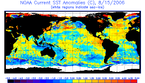
Next is the observance of a moderate El Nino setting up in the eastern Pacific Ocean. Notice a broad area of warmer than normal water (orange/red) tucked along the Central American coast. (click on the image to enlarge) These waters also sit over the equator tracking from the dateline eastward into the East Pacific. This set up is typical of El Nino autumns. A significant lack of tropical weather (storms and hurricanes) in these regions has allowed SST'S (sea-surface temperatures) to warm.

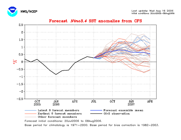
The next graph shows the forecast for the winter. Each line represents a weather model's output. The blue line is the mean of all of the models. This would lend support to the belief that an El Nino will be present through the 2006/2007 winter season.

Next thing to consider is the fact that we've already seen our first trace of snowfall for the season and October 2006's has given us temperatures -1.6°F below average (at the Chicago/Rockford Int'l Airport). Our average monthly temperature (up to October 16) has been 52.8°F compared to a normal of 54.4°F. During the El Nino winter of 1997/1998, much of the Midwest saw an unusually cold autumn followed by a very mild, dry winter. The similarities are too great to ignore.

The Official WREX-TV Winter Forecast for Northern Illinois/Southern Wisconsin is as follows...

November 2006: A few very generous snowfalls are expected. Temperatures will remain cooler than average (continued from October). Temperatures will average 2-6° below average with average precipitation.
December 2006: Near average precipitation is expected. Numerous snow events will be expected. A few very cold spells will be likely, especially early in the month with a slightly milder month expected overall.
January 2007: Below average precipitation is expected. Temperatures will be slightly colder during the first part of January, followed by milder temperatures late in the month. January's temperatures will likely average slightly higher than normal.
February 2007: Below average precipitation is expected. Temperatures will be remarkably milder.
March 2007: Below average precipitation is expected. Temperatures will be at or slightly above monthly averages.

Sunday, October 15, 2006

Southern Soaker!

Our chances of seeing the sunshine are slim to none the next few days, but rainfall may be more of the same!

Developing low pressure will track across the Ohio River Valley through the course of the next few days. Severe weather may be a possibility along the Gulf Coast with heavy rainfall possible from Oklahoma through Southern Illinois. A lot of times with these southern-track systems the rainfall comes down in copious amounts to our south, but limited moisture remains this far north! I have a hunch that three days worth of rain chances will only yield 1/2" of total rainfall.

The heaviest rainfall for Northern Illinois/Southern Wisconsin will be on Monday with lingering showers for Tuesday and Wednesday. Another system may spark a few few showers for Thursday (along with a small chance of flurries/snow showers for Southern Wisconsin early Thursday morning) before another cool down by the weekend. -ERIC

Northern Lights Timelapse!

Morgan Palmer, Meteorologist for KLTV in Tyler, Texas sent me a link to this video of the Northern Lights (Aurora Borealis) from British Columbia. It will almost put you in a trance watching it! Great video! -ERIC

Friday, October 13, 2006

Howling Wind for Friday the 13th!

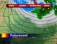
At 3:00pm today, winds were gusting around tropical storm force through much of the Upper Midwest! The center of low pressure is located near Sault Ste. Marie, Ontario this afternoon. Believe it or not, winds adjacent to the low aren't all that strong! We've got an area of high pressure that is developing now over Oklahoma, Arkansas, and Texas. As this intensifies, it brings a higher gradient between the high and low pressures. You can see that by looking at the isobars (lines of equal pressure) on the Futurecast to the left. The closer the isobars are on a map, the more wind is moving through the atmosphere. In this case winds are spiraling around the area of low pressure, so we've got cold, northwesterly winds! Once this low pressure exits (on Saturday) we'll see more pleasant conditions with moderating temperatures.

The problem with this storm departing is that another system will develop and move into the Great Lakes for early next week...essentially taking this one's place. However, none of the computer models are generating this much cold air. Thank goodnesss! -ERIC

Thursday, October 12, 2006

Walking in a Winter Wonderland!

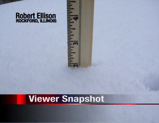
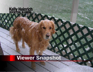
Falling temperaures on Wednesday. Snow falling on Thursday! Most Rockfordians woke up to a dusting to several inches of snowfall this morning! Some convective snow came in around 7am bringing down an inch on my front yard...and more in some places! Our normal high temperature for today is 64°. Today was anything but normal.

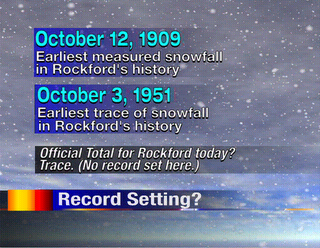
So, how rare is October snow here in Rockford? Looking back at over a hundred years of data, our earliest snowfall came on October 3rd, 1951 when flurries flew over the Forest City. The record earliest accumulating snowfall happened on October 12, 1909. If we would have gotten a little more snow recorded at the airport today, we would have tied a new record for the earliest measureable snowfall for Rockford.

While a few flurries are possible tonight and early Friday, I don't think we'll get anything like today's snow for quite a while. In fact, our weather pattern turns rainy and stormy next week. Not good news for area farmers who need dry weather to complete this year's harvest. -ERIC

Breaking a Few Records!

Today has already gone down in the history books for some places across Northern Illinois. Snow this morning came down in surprisingly heavy amounts...adding to about an inch just north of the Rockford metro area. Officially we've only seen about a trace so far (as of 1pm) at the Rockford Airport. But it was on this date back in 1909 that we picked 0.2" of snow...going down as the earliest measurable snowfall on record. If we see anymore snow, we could very well tie the record! However, it has already begun to melt from the peeks of sunshine earlier today.

On average our first snowfall is usually in the middle of November, but this year has already proven to be anything but average! -CANDY

Wednesday, October 11, 2006

Latest forecast: Warm and Dry Winter!

NOAA (National Oceanic and Atmospheric Administration) released its official winter forecast on Tuesday. You wouldn't know it by stepping outside in this week's cold, but we've got something to look forward to! (click on the image to enlarge) They are predicting much warmer temperatures for much of the upper Midwest, including the Rockford area!


However for you snow-lovers, it doesn't look like we'll see a repeat of 1979! The areas expected to see above-normal precipitation are in the desert southwest, Texas, Florida, and the Carolinas.

To read the entire forecast report, simply click here.

Freeze Warnings Posted!

With temperatures expected in the twenties the next few nights, the National Weather Service has hoisted Freeze Warnings for the entire northern Illinois/southern Wisconsin region. When temperatures are sub-freezing for several hours, the growing season will come to an end. So if you've got any houseplants outdoors, bring them in. Go out to the backyard garden and see if there are any tomatoes left and pick them. (Hopefully they'll ripen on the window sill.) Bring garden hoses indoors to prevent freezing/cracking. And finally, don't forget extra food, water, and blankets for our outoor pets.

To the left you'll find the official National Weather Service Wind Chill Chart. To read the chart, find the temperature at the top, wind speed to the left. Where those two lines meet, that is the wind chill...or "feels like" temperature.

Stay warm the next few nights! -ERIC

Tuesday, October 10, 2006

End in sight for the 2006 Growing Season

Temperatures are set for a free-fall during the day on Wednesday as a major system develops over the upper Midwest. Freeze Watches have already been issued for many of our counties for Wednesday Night. Temperatures are expected to dip into the middle 20s bringing an end to this year's growing season.

We'll be equally cold (perhaps even colder) for Thursday night as mid 20s will again be expected.

Incidentally, this killing freeze is 1-2 weeks ahead of schedule, climatalogically speaking. -ERIC

Monday, October 09, 2006

Major Arctic Blast!

A major early-season winter weathermaker will develop over the next 48 hours. Severe weather across Arizona, New Mexico, and far west Texas was the beginning on Monday.

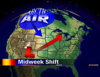
Low pressure will intensify as it rapidly moves into lower Michigan on Wednesday. This low will "bomb" out (meaning pressures will drop significantly) tugging an immense supply of cold air from the Northwest Territories of Canada.

Rain will begin on Tuesday night. But as the cold air filters in during the day on Wednesday rain will mix with or change to snow. Light rain/snow mix is likely for Wednesday night into Thursday as temperatures plummet.

Snowfall accumulations will be highly unlikely. Granted if the calendar read January or February I'd have a few inches in the forecast. Still, enough snow could fall to reduce visibilities just a tad...and remind us that winter is only a little over two months away. -ERIC

We're switching schedules!

If you were watching the show on Friday the news will come as no surprise. After nearly three years at WREX-TV doing morning weather, I will be moving to the evening shift starting next week. While I will miss Katie and the entire morning show crew, I am excited about the opportunities being Chief Meteorologist will give me. What an honor it will be to forecast the weather each night on the station I watched growing up!

I encourage you to keep watching 13News as we search for our newest weather team member. We'll be sad to see Mike MacGown leave us after such a short time. He is a great Meteorologist and I feel lucky to have worked with him.

Candice King and I are committed to bringing you the best forecast you can find. We also promise to be in touch. If you should need anything feel free to write, E-Mail, or call. Our E-Mail addresses are on our weather page at wrex.com or you can write to news@wrex.com.

Thank you so much for watching all these years! Without your continued support, I wouldn't be able to continue doing the job I love. Thanks again for that. :-) -ERIC

Thursday, October 05, 2006

Amazing Chicago Tornado Video

Last weekend, one of our Production Crew members showed me this video of a tornado over the city of Chicago. After consulting with the Meteorologists at the NWS in Romeoville, they determined that it was in fact a tornado! Check out the video below or read the whole story here.

(NOTE: The video contains some language that may be offensive to some viewers.)

Adding up just a little bit of rain

It may seem to most of you that we've been in quite a rainy stretch! Believe it or not we've seen rainfall six of the past seven days! However the rainfall has been quite light. That's good news because yesterday marked one month since the Labor Day Deluge! 500 people turned out last night for a party/fundraiser at the Teamster's Hall on 11th Street in Rockford. $10,000 was raised to help those who were affected by the 100-year flood.

Not much rainfall is in the forecast for the next week. After a decent warm up this weekend, rain chances will come back into view late Sunday night into Monday. -ERIC

Wednesday, October 04, 2006

Colors of Autumn

Now that autumn is upon us, many people look forward to the cooler weather and changing colors of the leaves. What a beautiful sight it is when you take a walk along a path in the forest or drive down a country road with trees on either side.

Leaves lose their color at this time of year, and the weather year-round plays a role in the loss of pigment and the onset of the beautiful hues of reds and golds. The shorter days in autumn is a signal that winter is on its way, and it is time for trees to begin the process of shedding their leaves. The production of chlorophyll, the chemical that gives leaves their green color in summer, is shut down and as a result, the green disappears and is replaced by other pigments that give the leaves their fall colors. -CANDY

Aurora Borealis is Back!


There should be great weather for viewing the Aurora Borealis (or northern lights) the next few nights.

Generally clear skies overhead and to the north have already allowed some folks in Wisconsin to take in the awesome sight. I saw the northern lights for the first time just a few years ago while coming back from the Northwoods of Wisconsin. The sight was so awe-inspiring I exited the interstate and stood outside the car for quite a while even though the temperature was near 0°F! The lights danced across the horizon...with mainly green and blue hues. I could have stayed out there forever (if it wasn't for the cold and the fact I had to get back to Rockford).

Enjoy a few more pictures and keep an eye to the northern horizon in the coming weeks and months! -ERIC

The little engine that couldn't

After such great severe weather hype, things never materialized yesterday. One of the things that set us apart yesterday was the cap that was in place. Oftentimes we talk about the cap in the summertime. As temperatures at the surface warmed into the 80s yesterday afternoon the atmosphere continued to warm as you went up 5,000-15,000 feet. In order to get efficient lift (needed for thunderstorm development) we need falling temperatures with height. This allows air parcels to rise forming clouds and rain.

Storms did fire early this morning, but most of the activity was located behind the front (and behind the juiciest airmass). Severe weather will be limited to places like Toledo, Columbus, Indianapolis, and Louisville today. -ERIC

Tuesday, October 03, 2006

Severe Weather Outbreak?


Things appear to be more in line for a possible severe weather outbreak later today! While most of the Northern Illinois/Southern Wisconsin area will be dry most of the day, an approaching cold front will ignite storms early this afternoon. Storms should enter the WREX-TV viewing area late this afternoon into this evening.

A "Moderate Risk" of severe weather is forecast from the Storm Prediction Center for nearly all of our area. You can see that depicted in dark red. A "Slight Risk" of severe is indicated in the bright red.

Keep in mind, we saw quite a bit of severe weather last night under a slight risk. Our chances will be increased today due to the proximity of a cold front and added upper-air support.

To read more about the risk of severe, click here.

Yesterday was quite a day! Thunderstorms developed right over the Rockford Metro with torrential rainfall and gusty winds, but just east of the official reporting station: RFD. Officially 0.73" of rain fell in the area but areas to our east saw quite a bit more! Chicago-Midway saw 2.21" while O'Hare had nearly an inch and a half.

One inch diameter hail was reported near Mount Morris and near the campus of Northern Illinois University as well.

We'll have to see if we're in the running for more severe today. Stay tuned!!! -ERIC

Monday, October 02, 2006

Keep an eye to the sky!

Northern Illinois/Southern Wisconsin is on the edge of the heat!

Often times we call this placement the "ring of fire." A frontal boundary will sag into Southern Wisconsin today providing the threat of severe weather. In fact, the Storm Prediction Center has placed a bullseye over us with a "Slight Risk." For more information on that, click on http://www.spc.noaa.gov for more.

What's even more impressive is the fact that we're in a slight risk for severe on Tuesday as well!

We'll be watching the radars closely during the next few afternoons/evenings. Large hail and damaging winds will be the main severe weather threats today and tonight. With the frontal boundary closer and enough upper level support, a small risk of tornadoes will also be present.

It's severe weather season. Hold onto your hats!